Iran Situation
Iran Situation
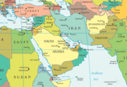
Iran known anciently as persia, was ruled in the sixth century B.C. by such powerful emperors as Dariush and Cyrus the Great. The land area is about 1,648,000 square kilometers. Iran is bordered North by the former USSR and the Caspian Sea (Khazar Sea), West by Iraq and Turkey, East by Afghanistan and Pakistan, South by the Persian Gulf (Khalije Farse) and Gulf of Oman.
Persian Gulf
The Persian Gulf and its coastal areas are the world’s largest single source of crude oil and related industries dominate the region. The countries with a coast line on the Persian Gulf are also Oman, United Arab Emirates, Saudi Arabia, Qatar, Bahrain, Kuwait and Iraq.
Land and Climate
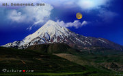
Most of this territory belongs to a central desert plateau 4,000 feet above sea level, rimmed with two major mountain chains. The Zagros Mountains dominate western Iran, while the Alborz Mountains are found in the north. Mountain Damavand, highest peak (at 18,386 feet) and an active volcano, is located in the Alborz mountain range.
The nation’s diverse terrain gives it a variety of climates. Summer generally extends from June to August. Winter is from December to February. However, these seasons vary in length and severity depending on the region.

